As our weather becomes more…interesting, you might find yourself wanting some extra info about weather patterns. You’ll be able to amaze your friends and families with your ability to prognosticate (hopefully with some degree of accuracy) upcoming weather events or changes.
Here is a very good site: http://www2.ucar.edu/
“The University Corporation for Atmospheric Research is a consortium of more than 100 member colleges and universities focused on research and training in the atmospheric and related Earth system sciences.” (from, About NCAR & UCAR)
To the left of the rotating images, you’ll see a place indicating “Real-time Weather.” If you click that, (or click here), you’ll find yourself at the home for Real-Time Weather Data.
If you click on the “Satellite” tab, you’ll have access to current GOES-10 and GOES-12 weather satellite imagery. On the right side of the web page, you should see a map of the United States. Selected cities are noted with code. For example, “EVV” is Evansville, Indiana, and “LIT” is Little Rock, Arkansas.
From the left-side radio buttons, choose “Water Vapor.” Note, we will only see imagery for the lower 48 states. Once you have Water Vapor selected, click on the “EVV” symbol on the map.

Water Vapor
Your image may not match precisely with mine. Why? Because I captured mine at 21:34:07 GMT and you might not try this until much later. This would be a good time to practice converting GMT to U.S. Standard Time, in my case Central Standard Time. GMT is +6 hours ahead, so I have to subtract 6 hours from 21:34:07, giving me 15:34:07 (2:34pm). And, I’ve got to add an hour for Standard Time (+1), resulting in 3:34pm CST. You may have to modify this depending on your time zone.
Let’s consider the image. The colored scale at the lower part of the image indicates temperature in Celsius. The warmer temps (yes, -10C is still pretty cold, but warmer than -80C) are in orange; the cooler temps in violets, blues, and greens.
Notice the dramatic change in air masses across the upper Midwest. A large cold front is pushing down from Canada into the Plains states. Let’s look at surface conditions.
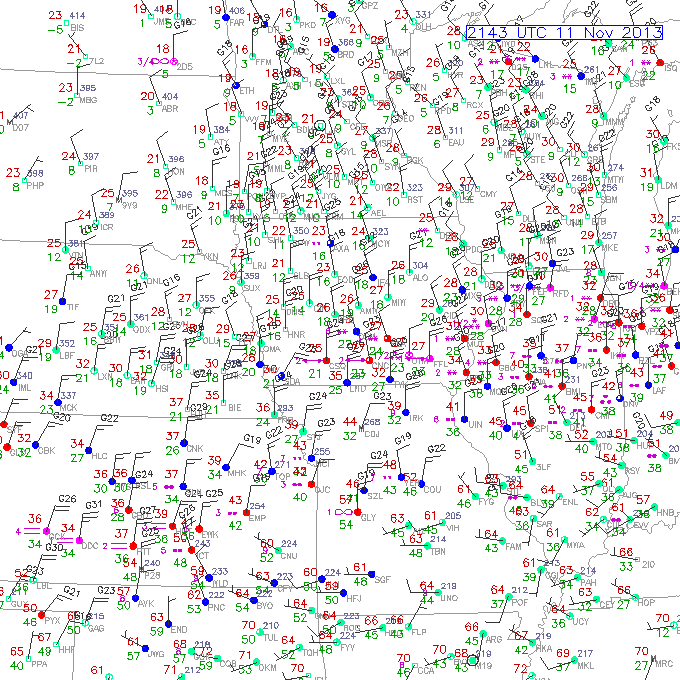
Look close. The light grey lines are the state borders. The above image covers portions of Kansas, Missouri, Nebraska, Iowa, South Dakota, and Minnesota. Examine the weather station symbols. Recall the station symbol notation: the shaft points in the direction the wind is from; the barbs indicate wind speed; the upper-left number is temperature (F); the lower-left temperature is Dew Point (F). Start in the upper-left corner of the map, examine the air temperatures, and move to the lower-right. Notice the 30, 40, even 50F degree temperature difference as we move from northwest to southeast.
Now, let’s see what is happening in the Upper Atmosphere, at 300mb pressure.
 This image perfectly illustrates the pressure gradient force. All of these isobars are measuring the 300mb pressure. Start at the bottom, and we’ll work our way north. Each station symbol has a wind vane, a temperature, and an altitude (in meters) but the altitude is missing the trailing zero, so you’ll have to make a mental note to add one. If we begin with the southernmost dark line, the index contour, the 300mb pressure level is about 9700m (31,824ft). As we read our way north, notice how the 300mb pressure level gets lower and lower. The index contour cutting across Tennessee is about 9460m (31,037ft), and as we cross into Canada, over Quebec the 300mb pressure level is about 8810m (28,904ft).
Another condition we can see on the map is a low-amplitude Rossby wave. Over the western U.S. we can see a ridge developing over northern California and Nevada, Oregon, and Washington. The Rossby wave then gently slopes into a low trough over Minnesota, Wisconsin, and Michigan. We also have a pretty good idea where the mid-latitude Jet Stream is located by examining the wind vanes. Note the red areas and examine the wind vanes. Most of the vanes point West-Northwest, with wind speeds of over 100knots. I notice some wind speeds are as high as 130knots (150mph).
Since the upper atmosphere tends to help direct the movement of weather patterns and air masses, maybe the Jet Stream will help drag the cold front off to the east before it reaches Kentucky and brings a bunch of cold weather.

I used to work there in a non-scientific capacity! Now I’m wondering why you don’t work there. Come to Colorado, sir!
LikeLike