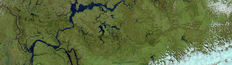
Flooding along Ohio River, March 2015
The above region depicted in the image above should be familiar to most of us in the United States. The blue “veins” are the regional arteries of part of our nation’s transportation network. Here, we can see flooding along the Ohio River near Henderson, KY. Also, small areas of flooding are located across from Paducah, KY., and west of Ballard, Co., KY., near Cairo, Illinois. If you would like to see a “before” image, visit NASA’s “Earth Observatory” website. We tend to forget rivers in the United States are as important as our system of interstate highways. People notice when roads fall out of repair; we drive on highways all the time. Few of us realize how vital our waterways are for global commerce, not simply for pleasure. Flooding, as well as droughts, can have long-term impacts on the movement of materials within the United States, or the delivery of materials to port facilities, in preparation for shipment to other countries.
Weather Journal for March 25th, 2015
Date of the observation: 3/25/2015
Time of the observation: 13:27 CST
Geographic location: Murray, KY 42071
Air temperature (units: F and C): 74° F / 23° C
Wind speed: 11mph (west-southwest WSW)
Relative humidity (%): 57%
Dew point (units: F and C): 59°F / ° C
Barometric Pressure 30.04in / 1017.27 mb
Heat Index/Wind Chill (units: F): 77° F / 25° C
Skies: Mostly clear, maybe 10% … right now.
Yesterday was the nicest day in weeks, mostly sunny with air temps in the low 70s.
Today is warmer than yesterday, with air temps in the mid-70s at the time of observation. We may be experiencing a little compression warming, which occurs when an air mass gets pinched between two denser air masses. A cold front recently cleared from our area, but a cold front is approaching our area. The air mass in the middle is getting squeezed and this can lead to slightly warmer temps.
Later today, tonight, and tomorrow our region is expected to receive a lot of rain, maybe inches or more by some forecasts. Cold air is moving in from the Plains and the air mass is colliding with warmer, moister air from the Gulf of Mexico. We all know what happens when warm air comes in contact with a cooler mass, we get condensation. We see this happen on the outside of our tasty summertime beverages. We could see a lot of rain from the collision of the cooler air mass with the warmer air mass.
One final note. Spring just began, and will run essentially through the end of June. Some of the questions I pose in the homework ask people to think about when certain types of weather occur, as in “what season?” When temperatures warm, when we get lots of rain, when we get the majority of severe weather, people tend to associate “warm” and “sun” with summer. Yet, summer may not be the precise season when some forms of weather are most likely to occur. Also, bear this in mind. The questions will state, “During what season do most <insert_phenomenon> occur.” The operative word is “most” as in “more than 50%.” Severe weather can occur year-round. However, the vast majority of severe weather occurs predominantly during two seasons.
PAX
