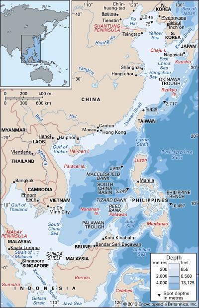
The Spratly Islands are a collection of atolls, reefs, islands, and skerries about midway between the Philippine Islands and mainland China. Navigation around and through the Spratlys can be tortuous; ships and boats have to exercise caution when traveling through them to ensure they don’t run aground on a submerged reef, or suffer damage from submerged rocks and reefs. For this reason the Spratlys are often referred to the “Dangerous Ground.” (The Spratly Islands: Dangerous ground in the South China Sea)
Westerners refer to this collection 750 marine features as the Spratlys, named for a British whaler Richard Spratly. Spratly sighted the islands in 1843 and was rewarded by having them named for him. I can say with some confidence residents of coastal China and Vietnam, plus the islands of Taiwan, Malaysia, Indonesia, and the Philippines already knew the islands were there. These islands are known by other toponyms, Nansha (China), Kapuluan ng Kalayaan (Malay), and Quần đảo Trường Sa (Vietnam). One of those examples where no one knows where anything is unless a British or Caucasian person was responsible for the “sighting” or “discovery” in spite of the fact the place is already fully occupied by people.

Spratly Islands (Source: CIA)
One of my concerns is how distracted the United States government has become by terrorism. Dealing with small groups who share drastically different political philosophies has been part and parcel of nearly every other country on Earth. Every country, from China, to Germany, to South Africa, has had to deal with small splinter groups who exercise terror as a political tool. The United States has some experience with violent domestic groups who sought popular influence through the use of violence. Examples include the KKK, the Pinkertons & early 20th century unions, the Black Panthers, the Weather Underground, and Timothy McVeigh. With 9-11, conservative politicians in the United States suffered what I can only conclude was a critical incident stressor so powerful their very DNA was altered. Today, much of politics seems to be viewed only through the Lens of Terrorism; “How does this policy address terrorism? Are we spending enough to secure our borders against terrorism? Are we spending enough on military to suppress terrorism? Are we supporting domestic spying in order to find the spies walking among us?” Our politics have become myopic, focused nearly exclusively on terrorism. The reality is, intelligent people everywhere will always be susceptible to others who seek to gain power through killing, torture, and beguiling the weak and desperate. Unfortunately, on a planet of nearly 7 billion people, a tiny percentage of our population is all that is required to ensure continual havoc and perpetual mayhem and give intellectually weak politicians reason to make life challenging and restrictive for everyone else.
We have to persevere, learn from the past to prevent making similar mistakes in the future; to adapt, modify, and evolve so each day is a little better than the yesterday. For the children being raised to be reasonable, responsible, rational adults. The 3 R’s.
For as our U.S. politicians continue to succumb to fear and ethnic-based bigotry, other countries not so easily distracted expand their economic, social, and scientific influence.

“Zonmar-en” by historicair 16:23, 22 April 2006 (UTC) – Adapted from Image:Zones maritimes UNCLOS.jpg by an anonymous user. Licensed under CC BY-SA 3.0 via Wikimedia Commons
China is very close to taking over the South China Sea. When I say “taking over,” my opinion is China will allow Vietnam, Taiwan, the Philippines, Indonesia, and Malaysia their 12-mile territorial zone, plus the 12-mile contiguous zone allowed under international law. What China will challenge is the 200-mile economic zone allowed to each country with a coastline.
No one should be surprised by China’s actions. Concerned, of course, but surprised? Not at all.
What does China have to gain from control of the South China Sea?
We might be tempted to think controlling and managing shipping and commerce throughout the sea is their primary interest. I don’t think so.
The South China Sea is fairly shallow as far as seas go. A few deep trenches exist but the average depth of is about 1212m (about 4,000ft. Source: http://www.coi.gov.cn/scs/introduction/gaikuang.htm). In comparison, the average depth of the Gulf of Mexico is about 1615m (about 5,300ft. Source: http://www.epa.gov/gmpo/about/facts.html#depth). The South China Sea is about 1/3rd larger than the Gulf of Mexico. A few deep trenches are also scattered about the Gulf of Mexico, very similar to the South China Sea.
My sentiments are China seeks to control many of the small Spratly Islands, establishing small populations and permanent settlements. Like Israel’s colonization of the West Bank and the Golan Heights in violation of almost every agreement or accord, China is essentially seeking to colonize the South China Sea. Their desire to settle and control the islands is not related to population growth specifically; the Chinese government is not looking for room to grow, in other words.
The United States Energy Information Administration reported in 2013 the South China Sea had “11 billion barrels of oil and 190 trillion cubic feet of natural gas in proved and probable reserves.” (US EIA) However, these estimates were based on estimates from exploration in undisputed territory.
If China could successfully colonize and build-out onto strategic few of Spratly Islands, China could potentially turn disputed territory into undisputed territory. Who will have the capability of matching China’s navy? Vietnam? Taiwan? Japan? China does not have much of a navy, to be clear. They don’t need much of one. No country in their sphere of influence has much of a navy, either. China has a bigger navy, though this is similar to saying my Brittany Spaniel is larger than your Chihuahua. The United States has mastiffs, to keep the analogy running. The Chinese government has been modernizing their fleet over the last decade or so. Even Chihuahuas can have a nasty bite.
Once control and influence is gained over the Spratly Islands, then all of the energy resources surrounding those islands then becomes the domain of China. The energy reserves unknown or only estimated then have a better chance of being fully realized – by China. The issue is China may not have true territorial claim, making the confrontation of who owns the islands a case of Might Makes Right. By building on the islands China effectively usurps any other claim to the islands by Malaysia, the Philippines, Vietnam, or Taiwan. Again, similar to how Israel has built on the West Bank of Jerusalem.
China is not especially concerned about the islands due precisely to population growth. Energy use and needs is directly related to population, though, and by assuming control of the islands China is simply protecting long-term energy prospects. Eleven billion barrels of oil seems like a lot; in 2014 the United States used about 7 billion barrels (US EIA). The proven oil reserves in the South China Sea would last the United States about 1-1/2 years if my math is close. In 2013, China is estimated to have consumed about 4 billion barrels of oil.
As for natural gas, in 2014 the United States consumed about 27 trillion cubic feet of natural gas. The proven reserves of natural gas in the South China Sea would last the United States about 7 years, again if my math is close.
 An easy estimate would be the proven reserves of oil would last China couple years. The reserves will last somewhat longer as they can only be drawn out at a certain rate. China is also a net importer of both oil and natural gas. In 2012 China consumed about 5.2 trillion cubic feet of natural gas. 190 trillion cubic feet sounds like Chinese citizens would be OK for about 36 years – if not for their increased demand for energy.
The South China Sea is China’s Gulf of Mexico. China does not refer to the South China Sea as the “South China Sea.” They simple refer to the vast body of water as the “South Sea,” as if including “China” in the name is redundant, extraneous. “It already belongs to us. What efficiency is added by stating the obvious?” Each of the countries bounding the South China Sea have their own name for the water body. The Philippines refers to this body of water as the “West Sea.” Vietnam calls the same water body the “East Sea.” On thing is certain; few countries possess the ability to stymie China.
The Fog of War
I spent some time doing what we in the business call “visually scrutinizing data” which really means I spent a couple of hours checking out Google Earth. Google Earth is one of the best products on the Internet and if you don’t have GE installed on your computer, you must do so at your next opportunity.
Use the “Search” box and enter “spratly islands.” The view will display the Earth, rotating west-to-east while focusing upon the South China Sea and the Spratlys. The seamounts, islands, atolls, and reefs will be quite apparent at an “eye altitude” (lower-right) of about 490 miles. As you change scale, zoom-in, notice some islands become very visible, others not so much. In fact, some islands become quite obscure.
Why are some islands clearly visible down to a couple hundred feet and other islands nearby are obscured by the “fog of war?”
 Notice the white text near the lower-center of the image (left). Data providers are interesting. We can see the U.S. Navy and NGA have some role in data acquisition. The U.S. Navy has a special branch located within the Stennis Space Flight Center complex in Mississippi. NAVOCEANO is a special Navy installation with a primary responsibility of mapping the oceans. Getting an aircraft carrier stuck some place is not only embarrassing but time-consuming to un-stick.
NGA stands for the “National Geospatial Intelligence Agency.” The NGA provides many government agencies data and intelligence from numerous air and space-based sensor platforms. Essentially maps. They produce maps for the Department of Defense and all branches of the armed services, the White House, the Department of State, and many other federal offices, agencies, and departments. These are good jobs, fascinating and intellectually stimulating jobs, with opportunities for travel, to interact with people from around the world. Some of my former students have been to Afghanistan, Iraq, Saudi Arabia, Israel, Italy, Hawaii, Colombia, Mexico, and Germany. They have worked with Colin Powell and White House staff over the years. Very high-level stuff.
Based on what I can glean from conversations with former students and my own interests in military applications of sensor systems and cartography, my guess is Google Earth has been scrubbed of some data either by request of the Chinese government or perhaps at the request of our own government. So, yeah, not a great leap of intellectual effort, I agree. The data is there, obviously, but has been blurred by the Fog of War. Or, at least the Fog of Conflict, maybe.
Geography is not simply about countries and capitals, water bodies, and mountains. Geography is about understanding where things are, and why they are there. The where is typically very easy to answer. The why is makes for great conversations, research, and study.
PAX
