Drones have many applications, are considered by many fields and disciplines to be incredibly useful tools. In my first post, I provided an overview of many issues associated with drones. In closing my first post I hinted I would author future posts, offering some current or potential uses. Some of the applications I identify are currently uses, with potential for growth; other applications are more future-looking, not in place today, but perhaps in the not-so-distant future.
In my second post, I discussed another field where drone use is opening doors to new exploration techniques. Archaeology is finding many uses for remotely-piloted aircraft, or unmanned aerial systems (UAS). Kites are being equipped with digital cameras. Balloon kits allow researches to hoist digital cameras aloft. More detailed archaeological surveys mandate stability unattainable from kites and balloons. The survey of archaeological sites must be systematic. Flight lines need to be planned in advance of a survey to ensure capture of the area of interest (AOI). Scale of acquired imagery needs to be established. Scale and resolution of acquired imagery must be considered before flying a drone. When the details of the mission have been thoroughly accounted, then imagery is acquired. With regards to UAS, several missions might be flown. The first mission might result in imagery, visually inspected, to help plan the geographic scope of future flights. Sometimes, interesting landforms which imply a culture imprint can only be seen from above which might impact the scale and scope of later drone missions. In Europe, especially in the U.K., France, and Eastern Europe, drone use has improved the knowledge of culture imprints on the landscape, aided in the inventory of archaeological sites, aided in the detection, analysis, and interpretation of archaeological sites.
 I ask students in my all of my courses what color they see the most when they are outside in the late spring or early summer. Sometimes, they need some prompting; “What is the color of the vegetation you see when you go outside?” Usually, the answer is “green,” which is sort of wrong. I’ll explain why.
From high school physics, we learned about the Electromagnetic spectrum (EM). The EM spectrum is the range of energies emanating from the Sun and other objects. Our eyes, great as they are, are sensitive to a mere fragment of the entire spectrum of possible energies. The rods and cones in our eyes are stimulated by energies associated with colors ranging from violet to red. A simply mnemonic to remember the colors is ROY G BIV (red, orange, yellow, green, blue, indigo, violet). The arrangement is from longest wavelength to shortest wavelength.
 Our eyes are not sensitive to other energies, like radio waves, cosmic waves, x-rays, microwaves, or even energies just beyond the normal range, infra-red, or ultra-violet. Our natural environment, however, is very adept at reflecting energies beyond the range of our eyes to see.
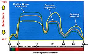
At left, is a graph illustrating the reflectance of energy from the leaves of healthy vegetation, stressed vegetation, and severely stressed vegetation. “Stressed” means the vegetation has been affected by something, lack of water, lack of nutrients, presence of insects, or some form of blight.
Note the range of reflectance energies along the y-axis, and the range of reflectance wavelengths along the x-axis. Along the x-axis, we see the “visible” range, the range our eyes reacts to, the “near