“Geospatial Technologies Attracts Everyone” was intended to be a long article about the “geospatiality of all things” but I’ve opted to break once article into a series, mostly for easier reading, but also to publish more frequently.
THE GEOSPATIALITY OF EVERYTHING
Life is All About Location and Data
I had a trouble adapting the subtitle above. Life is about location and data, really. People will argue with me about this, a situation I find equal parts astounding and frustrating. “You are simply confusing economics with geography,” I’m told. Or, “Geography can’t be made out to be about everything, you know. You’re reaching.” Perhaps I’m guilty of drinking my own Kool-Aid, of being a victim of my own hubris, dogma, and bias, but when those phrases are uttered I simply believe the person speaking them lacks vision and hasn’t overcome their own ignorance, yet. Most of these comments stem from memories 4th grade or 8th grade geography which consists of memorizing states and capitals, countries and capitals, and a few mountain ranges and water bodies. These exercises are similar to learning how to add and subtract and then espousing to know all there is about mathematics. The surface doesn’t show any marks so little has been scratched.
My world geography students tend not to like how I teach world geography. I don’t like to teach “this is this, and that is that,” and then test their ability to regurgitate back to me “this” and “that.” The world has many levels of grey. Few completely white areas exist, few completely black areas exist. While I can give them map quizzes so they can achieve some ability of where things are in relation to other things, other geographical concepts are considerably more murky, less tractable.
Life is complicated. Location and knowledge (data + information) brings about probabilities and potentials and unexpected outcomes. The question arises, “How can we mitigate against the unexpected?” As an answer I would say, “By asking more questions; then, take any answers or resulting data and make some maps.” The map-making pursuit, i.e. cartography, is the third installment in my series on how geospatial technologies are attracting everyone.
Cartography is one of few disciplines allowing the person involved to utilize both their Right and Left Brain talents. To do cartography one must crunch data, distill out some numbers, and be able to relate these numbers to a geographic location or some sort of enumeration unit. Then, one must tap into their creative nature, their sense of color, organization, depth, composition, and be creative when developing a map for a particular audience. Except for the recent revelations Left vs. Right Brain activities are pretty much myths. (“The Truth About The Left vs. The Right Brain Relationship;” NPR) Multi-tasking is a myth, too; at least the way most people define multi-tasking. But I digress.
Today, a fairly decent array of apps and software is available for free or inexpensive through an app store. I am not going to attempt to review all of these offerings; the fact there are offerings, period, supports my thesis. My objective is to showcase a few applications to highlight just how accessible mapping technology is to the general public.
In 2013, President Obama unveiled his ConnectED initiative. ConnectED is a broad collection of activities and programs designed to encourage students and teachers to become more engaged in science, technology, engineer, and mathematics (STEM). ConnectED is not simply geared to towards students as many rural school districts still struggle with internet access, in general, slow or limited bandwidth in specific areas.
Here is a link to the ConnectED Fact Sheet.
One of the benefits from ConnectED comes from ESRI (Environmental Systems Research Institute.) ESRI is the world’s leading purveyor of geospatial software and applications. ESRI’s software is found everywhere, from utilities, oil & natural gas exploration, business and commercial companies, archaeology, geology; you name it, there is a way to map it and ESRI is probably there. Jack Dangermond, CEO of ESRI, was recently featured in Forbes (March 2015), as ESRI is very interested in sustainability and monitoring natural resources.
ESRI is very interested getting young people involved in science, though. My intent is not to make this piece about ESRI, per se; I am the local ESRI higher education site license administrator, the local higher education contract administrator, the local ESRI/GIS higher education advocate, and the local K-12 geography advocate (in part as my role as a self-identified “geomentor.”) I am picking out ESRI expressly because of their effort to improve STEM resources in K-12 and promote spatial learning in K-12 by partnering with the Obama White House’s ConnectED initiative. ESRI deserves some recognition as they have made some very cool mapping apps available for free to every public school in the United States.
And, you can have a free 60-day account, too, to try. Everybody can. Everybody… And a home version can be purchased for $100.
All public schools, and some private, have access to ESRI’s ArcGIS Online for Education. Generally referred to as ArcGIS Online for Organizations (AGO), being in education I modify the title slightly. Judging from my experience in Kentucky, a very small percentage of teachers are aware of the treasure their school district has access to. Most of my friends and contacts are all associated with education. They report having no idea about this “ESRI” or “ArcGIS” I ask them about.
If you have time and have an interest in turning numbers in maps, visit ArcGIS Online for Organizations and get a free trial.
ESRI offers educators at all levels opportunities to learn, explore, develop, and get involved in teaching geospatial concepts to students of all ages and all abilities through their ConnectED program.
This video does a pretty good job of showcasing the work of students at Roosevelt High School in East L.A., California.
http://video.esri.com/iframe/2539/000000/width/480/0/00:00:00
I was sitting in the audience listening to their efforts; Will.I.Am was present, as moral support but also advocating both for these kids, for their teachers, but also calling for people to get involved in helping young people get more involved in their world, to use technology, and to share their knowledge. These kids inspired me to get more involved on my campus and in my local school systems.
A fellow faculty member and I wrote a small grant proposal to help bring geospatial knowledge to teachers. We both realize rural communities need special assistance in promoting geospatial awareness to teachers and to encourage teachers to integrate geospatial exercises into their lessons for their students. Our grant was funded, fortunately, and we set about developing a couple of workshops to help introduce geospatial knowledge upon a willing audience. Our long-term goal is they will themselves become “geomentors” to young people, or act as geospatial contacts in a business community to help increase our societies geospatial knowledge base.
We recently completed our first preliminary workshop for a small number of people. We introduced them to geospatial technology using resources developed by NASA and their education partners (For Educators | NASA).
A good collection of videos for geoN00bs are available from Penn State Public Broadcasting. The “Geospatial Revolution” video series are nearly 5 years old, somewhat dated, but still are a good place to start, to ease in to how geography infuses all the things.
Later in the day, we distributed several new Trimble Juno 3B GPS units to our participants. Outside, in the cool sunny April air, I set about giving them the bare minimum details to help them capture points with their units. I say bare minimum because we live in the Age of Inquiry-based Learning. What this translate into in real terms is teachers provide the barest essentials of direction and students must then work together or alone to discern the True Nature of All the Things.
“OK; I have shown you how to turn on the unit. I have shown you what app to use. I have shown you how to launch the app. Now, comes the hard part: go map something.”
“But, you haven’t shown us how to use the software. How are we to map something if we don’t know how to use the software?” the students inquired.
“Not my problem. Figure it out. Yesterday, I took a random unit from a box, came outside, taught myself how to work the unit, capture edge-of-pavement around that (pointing) parking lot, and captured the building footprint of that building (point in a new direction). I did this in under 90 minutes. I am not special, nor gifted. Working alone or in pairs, you should be able to figure this out.”
And to their credit, they did figure out how to work their units, collect some points, save their points to a file. Took them about 60 minutes or so.
I ran them back up to our 3rd floor computer lab and helped them load their points into ArcGIS Online for Education. Kentucky has a state-wide license for higher education, and a state-wide license for K-12 education. The previous day I spent partially getting their AGO accounts created, a trivial endeavor, really. The participants sat down at their preferred workstation, used the information I provided to sign in to their AGO accounts. Within less than 30 minutes each participant was looking at the results of their ad hoc GPS-based mapping project. They discovered their data was editable; they discovered their symbology was changeable. I demonstrated their work was potentially shareable with the entire world, either by sharing a link, or by embedding their mapping project into an external website.
More importantly, perhaps equally as important, they learned this online application worked simply through a browser; no software download was necessary. We did have to upload data, though this was a simple task due to our network speed and the small size of the file to be uploaded. Additionally, AGO has the ability to reach out and touch publicly available GIS data anywhere in the world.
See, and I apologize for some of the hyperbole above, the “cloud” is making mapping, GIS, and cartography widely available not only for mapgeeks but also for anyone who gets the whim to make a map. ArcGIS Online uses a browser app to build a map, a map which can be publicly or privately shared online with others, using data from servers anywhere in the world, from data on your local hard drive, your local network, your distributed network, or from any number of public or private GIS map servers.
And that is fantastically cool!
ESRI and Google Earth are dating. Or at least they have become pals and roommates. Google Earth is discounting some of its enterprise mapping products, Google Earth Enterprise and Google Maps Engine. Google is providing a means to shift users to some offerings ESRI is making available for free. (Google Earth Alternatives from ESRI; ESRI)
ESRI also offers a Silverlight-powered browser-based mapping app, ArcGIS Explorer (link). ArcGIS Explorer, like ArcGIS Online, allows users to make some pretty cool maps from existing data floating around in the “cloud.”
To this point, I have ignored such services as Mapblast, Yahoo! Maps, both Bing and Google Maps, plus have also chosen to ignore map apps like Apple Maps. These are superficially simple map applications with all the heavy lifting occurring behind the scenes. What I mean by that is the map app connects to servers in operating in the cloud, run a very fixed collection of functions, like route-finding, dinner-finding, bus-finding, finding-finding. The end-user doesn’t really determine what is mapped, how it is mapped, how the map is made, what the map shows, and certainly don’t get to add their data. All of the map-making takes place on the back-end, server-side. By superficial, I mean the user requires little knowledge or sophistication about the mapping app, other than to realize their smartphone “location” needs to be active. By design, these apps are simple for the user because the real work happens back at headquarters, e.g. Apple, Microsoft, Google, etc.
Admittedly, the distinct I make between services such as Mapblast and ArcGIS Online may seem trivial, but it is not. Apps like ArcGIS Online allow the end-user to make their own custom maps, using their own custom data, build Powerpoint-like presentations atop active map data, with the ability to generate HTML code for embedding their map into a personal or corporate or school website. ArcGIS Online has a learning curve but if a 10- or 11-year old can figure out how to publish an online map, nearly anyone can.
Here is a sample map application put together by students at the T.K. Stone Middle School, Elizabethtown, Kentucky. *Please note: my version of WordPress does not support javascript thus embedding iframes is pretty much impossible. By clicking the link below, their web app should load in a few seconds, depending on the speed of your broadband.
T.K. Stone Middle School GIS Tour
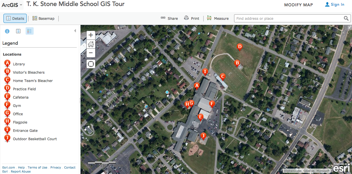 Here is a screenshot of what you should see when the app loads (left).
One truly significant hurdle stands in the way of assisting kids in their exploration of geospatial knowledge. Most schools have no one on premises who knows how to access their school district’s ArcGIS Online for Education account. I personally have spoken to numerous principals, assistant principals, science teachers, and district technical coordinators and no one has any idea of what their school system has at their disposal, let alone has heard of ESRI or ConnectED.
Sad.
But, parents are taking it upon themselves to introduce geospatial knowledge to their kids. Sometimes, it’s through a GPS, like one purchased at Wal-mart. Or, some parents show their kids how to use GPS-enabled fish-finders on their fishing boats. A good introduction to geospatial knowledge and awareness is Google Earth. Some kids can pick up where Mom or Dad left off and begin hacking their own maps. Google Earth has an API for learning to hack their maps.
Some savvy teachers in middle and high schools who have some college experience are introducing their students to mapping and geospatial knowledge. A few of my students were education majors who saw my demos, stayed in my class long enough to learn something, or perhaps took an online course specific to some aspect of geospatial learning.
I know I focused on ESRI products throughout this post. ESRI is not the only supplier of GIS products or the end-all, be-all of geospatial education. They do offer some user-friendly apps for Android, iOS, and tend to have an important role in setting industry standards for geographic data. iGETT, the Integrated Geospatial Education & Technology Training organization helps two-year colleges develop spatially-enabled workforce skills.
Open source options for mapping and GIS are also available. Quantum GIS (QGIS) is perhaps the most popular open source GIS software. QGIS is not user-friendly for the masses; the learning curve in spite of a bunch of forums, documentation, and videos is still pretty steep.
Location and mapping is the third most important bit of technology affecting all of us, and one we also have some ability to use to our benefit. While some of us may not care about drones and UAVs, we should care about location, data, and mapping. These elements are critical for city services, like police, fire, and ambulance service. These elements are fundamental for managing urban assets, like storm water drainage, signage, lighting, and managing property. Location, data, and mapping have become a part of our daily lives, if only for finding alternate routes around a traffic jam, or for finding the nearest Starbucks.
Thanks for reading. I appreciate comments, insights, or anecdotes.
My next post will be a geographical review of Lee Child’s novel, “A Wanted Man.”
PAX
